Andaman Islands
Jump to navigation
Jump to search
archipelago in the Bay of Bengal   | |||||
| Upload media | |||||
| Instance of | |||||
|---|---|---|---|---|---|
| Part of | |||||
| Location | |||||
| Located in or next to body of water | |||||
| Has part(s) |
| ||||
| Area |
| ||||
| Elevation above sea level |
| ||||
| official website | |||||
 | |||||
Maps
[edit]-
 detailed map of Andaman Islands
 -
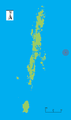
 Blank outline map of the Andaman Islands.
 -
 Outline map highlighting location of North Andaman Island.
 -
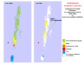
 Outline map highlighting location of Middle Andaman Island.
 -
 Outline map highlighting location of Baratang Island.
 -
 Outline map highlighting location of Strait Island.
 -
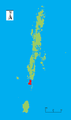
 Outline map highlighting location of South Andaman Island.
 -
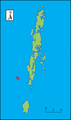
 Outline map highlighting location of Little Andaman Island.
 -
 Outline map highlighting location of North Sentinel Island.
 -
 Outline map highlighting location of Ritchie's Archipelago.
 -
 Outline map highlighting location of Rutland Island.
 -
 Outline map highlighting location of Barren Island.
 -
 Outline map highlighting location of Narcondam Island.
 -
 Andamanese tribal and linguistic map (1923)
 -
 Andamanese indigenous peoples- comparison of territory distribution, pre-18thC vs present-day.
 -
 USGS diagram showing the tectonics of the Andaman Sea region.


Images
[edit]-
.jpg/84px-Andamanen(Satellitenaufnahme).jpg) satellite photo of the Andaman islands
satellite photo of the Andaman islands -
 satellite photo of the Andaman islands
 -
 NASA photo of Little Andaman Island, from 1990 Space Shuttle mission
 -
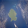
 NASA photo of North Sentinel Island, taken in 2003 from International Space Station.
 -
 NASA photo of the active volcano Barren Island, taken in 2003 from International Space Station.
.jpg)


